IB Geography Paper 1: tips for approaching the exam with confidence

Your IB Geography exam day is coming soon, but you’re still not sure how to approach it? Don’t worry, you still have time to master effective exam techniques. First things first, let us show you how to ace IB Geography Paper 1. It sets the tone for the entire external assessment, so getting it right is crucial for building your confidence and ensuring a strong overall result.
Need help with IB Geography?


IB Geography Paper 1 and its weight in your final grade
A successfully completed first stage of your external assessment will contribute 35% to your final grade. To write paper 1, SL students have 1 hour and 30 minutes. Their peers from HL must provide their answers within 2 hours and 15 minutes. This difference is due to the fact that HL studies three optional syllabus topics while SL – only two, and the assessment covers all of them.
The number of marks awarded is also different depending on the level. It is 40 for SL and 60 for HL.
IB Geography Paper 1 structure
Let’s imagine that your IB Geography SL course featured these Option topics:
Option A: Freshwater
Option B: Oceans and coastal margins
When you receive your IB Geography Paper 1, you need to find exactly these two options. Each of them will have the following structure:
- Section A – a series of short questions (typically worth 1-3 marks each, with a total of 10 marks awarded) based on a visual (such as a map, aerial photograph, diagram, etc.);
- Section B – an extended question from the choice of two. This section brings 10 marks.
For example, you might need to work with a map, which shows river floodplains and wetlands. The first section may require you to answer questions like:
- Describe two features of this river (2 marks);
- Specify one threat to this area (2 marks);
- Suggest three ways in which the local population can benefit from the areas along the river (2 marks for each way, total 6 marks)
When it comes to Section B, you might be required to write an extended response examining the impact of humans on river hydrographs OR explain how the community can solve the problem of water scarcity. As you can see, there are two extended questions in this section but you need to answer only one.
These were examples of questions for Option A: Freshwater. You will encounter the same structure for your Option B: Oceans and coastal margins.
At HL, the structure of IB Geography Paper 1 is similar. However, instead of two question sets related to two Option topics, you will cover three.
Make sure to take a look at these sample Geography papers to learn more about the Paper 1 structure.
Mark scheme of IB Geography Paper 1
When it comes to section A of each Option Topic, you will earn marks based on how correct your answers are. This section is less about analysis and more about demonstrating your knowledge and skills, such as map reading or graphic interpretation.
Section B essay questions, in contrast, are the opportunity for your critical thinking and logic to shine through. To earn 10 marks for each essay, you need to meet the following standards across four assessment objectives:
- Provide and explain relevant examples, statistics, and details (AO1: Knowledge and understanding of specified content);
- Your evidence must support your arguments and discuss exceptions and comparisons;
- Include correct and relevant terminology (both relate to AO2: Application and analysis of knowledge and understanding);
- Provide a conclusion relevant to the question and aligned with evidence;
- Specify the strengths and weaknesses of your evidence (both are AO3: Synthesis and evaluation);
- Have a logical structure, where every main paragraph discusses only one argument and information is consistently grouped;
- Provide maps, graphs, and other visuals to support your arguments, wherever it is appropriate to the question (both are AO4: Selection, use and application of a variety of appropriate skills and techniques).
Your marks might be deducted if you:
- Only describe or outline, but don’t explain your evidence;
- Provide a one-sided analysis or unbalanced conclusion;
- You discuss but do not explain different perspectives on your evidence;
- Your structure is inconsistent;
- Your visuals don’t follow the conventions or include irrelevant interpretations.
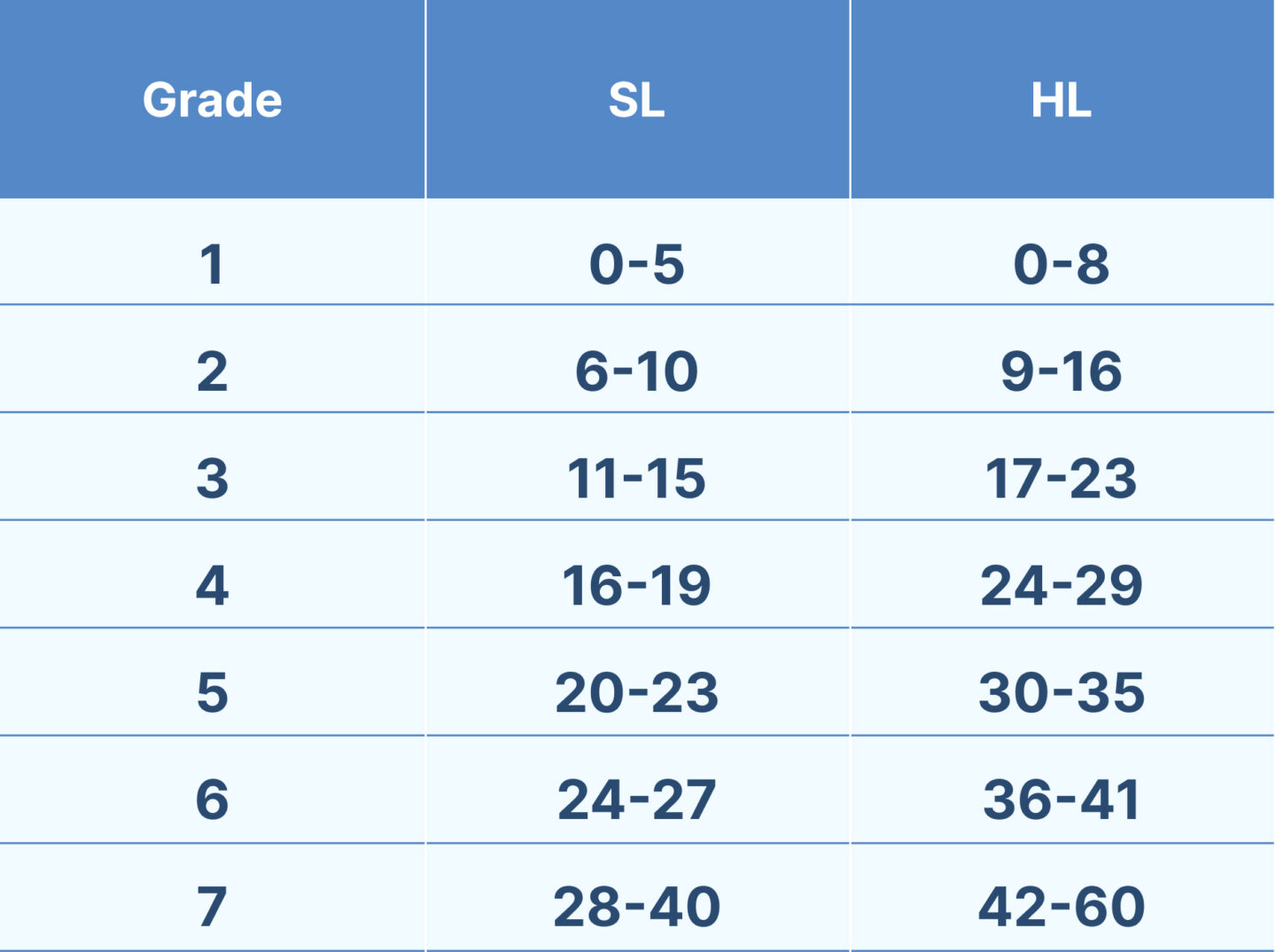
Based on the number of marks you receive, you can get a specific grade for IB Geography Paper 1. In 2024, grade boundaries were the following, although you must keep in mind that they change every year based on the overall performance:
IB Geography Paper 1 topics
You can expect your Paper 1 to cover all Option topics you learned during your two years of IB Geography. SL students study 2, and their HL counterparts 3 topics out of the choice of:
- Option A: Freshwater;
- Option B: Oceans and coastal margins;
- Option C: Extreme environments;
- Option D: Geophysical hazards;
- Option E: Leisure, tourism and sport;
- Option F: Food and health;
- Option G: Urban environments.
Thus, your Paper 1 will have two (or three) question sets, each focusing exclusively on their respective Option topics.
Type of Paper 1 questions
Each question set in Paper 1 has two distinctive sections. Section A provides a visual and a few structured questions requiring short answers. All these questions are connected with the same idea (for instance, they concern a specific location) and are based on the same map, graph, data set, etc. You can expect the following command terms:
- Briefly describe (natural features, characteristics, patterns, etc.);
- Outline or identify (threats, solutions, reasons, etc.);
- Suggest (ways, solutions, reasons, etc.);
- Explain (benefits, advantages, disadvantages, etc.);
- State (impacts, factors, compass direction, etc.);
- Distinguish between (strategies, solutions, policies, etc.);
- Estimate (a distance, direction, density, etc.)
These types of questions don’t require complex answers or analysis. You will typically have 2-4 such questions for each Option topic. It shouldn’t take you more than 15-20 minutes to complete each of these question sets.
An extended question, on the other hand, is a challenge to your critical thinking and analytical abilities. Here, you will need to write a mini-essay, in which you provide your opinion or hypothesis, consider the issue from more than one side, discuss its importance, provide evidence and examples from case studies, evaluate your arguments, and wrap everything up with a conclusion. You will have around 25 minutes to craft each essay, so being brief yet convincing is the key.
Here are some command terms you are likely to encounter:
- Examine (the impact, relationship between, patterns, etc.);
- Evaluate (the contribution, cost, success of attempts, policies, strategies, etc.);
- Examine (the reason why something is disputed, opportunities and challenges, importance, role, impacts, etc.)
Tips on how to ace the IB Geography Paper 1 exam with high results
And now it’s time to give you some practical tips on how to write your IB Geography Paper 1. You’ll find out things to consider when revising, as well as how to structure your reply and what you should and shouldn’t include in it.
1. Practice IB Geography past papers
Regularly working through IB Geography past papers is one of the most effective ways to prepare for your exam. Besides giving you confidence in answering different types of questions, they can also sharpen your analytical skills and improve your time management.
Questions you’ll face in Paper 1 are very much similar to those in past prompts. As you review multiple papers, you will notice common command terms and question types. Basically, all structured questions revolve around graphics or maps, definitions, or brief explanations. If you know these patterns, coming up with good responses on your exam shouldn’t be a mission impossible.
We suggest starting to work with past questions without putting time pressure. Just let yourself focus on understanding the questions and applying your knowledge to answering them. This approach can help you build your skills without much hassle.
Introduce time constraints only when you feel comfortable with the content and question styles. Timing yourself should help you see how long it takes to answer different sections. Typically, the first section featuring structured questions (where you need to work with visuals) takes less time than crafting an essay for section B. In your case, things might be different, but you need to understand your own pace. This way, you can plan your time better during the actual exam.

After answering each question, it is a good idea to check your work against the official mark scheme. You surely want to understand where you gained or lost marks. Examiner reports are one more useful resource since they highlight frequent errors, such as misinterpreting command terms or failing to provide examples.
2. Read and analyse maps
The first section of Paper 1 is almost always based on some sort of visuals. More often than not, these are maps of various types. It goes without saying, you need to be able to read those maps. If you have no idea what orientation, scale, symbols, contours, and other components mean, you will fail to extract any useful information for your answer.
And this leads us to tip number one – learn to identify maps’ key features. Every map you see on Paper 1 should show orientation and scale so that you can accurately measure locations, distances, and sizes. Symbols and colour codes vary by map type, and it’s your job to translate these visual cues into geographic meaning. Luckily, you should find explanations in the legend, so make sure to carefully examine it.
Speaking about map types, there are dozens of these, but you are likely to work with the following:
- Isoline/Isopleth Maps;
- Choropleth Maps;
- Topological Maps;
- Topographic Maps;
- Dot Maps;
- Flow Maps;
- Thematic Maps.
All of them have unique features and ways to represent data. Therefore, your task is to include as many types as possible in your revision and get comfortable reading them.
So, what do these maps show that you need to decode? First of all, you should be able to spot patterns. These could be, for example, concentrations of resources in one area. Along with this, you may notice some trends – are land uses in the north clustered while they are dispersed in the south?
Good responses identify these patterns and trends and support them with precise data, such as “Grid D4 shows ten dwellings within a 1 km² area, compared to only two in C3”.
Does something stand out as unusual? For example, there is a sudden drop in population in one spot. You might be required to note such outliers in your response and speculate about their reasons. Acknowledging such anomalies will demonstrate your critical thinking.
Some questions might ask you to pull numbers from a map, such as calculating distances or comparing values. Be ready to use the scale to measure real-world distances or estimate data from symbols. For example, a proportional symbol map might show city populations, and you could compare symbol sizes of two locations to estimate differences. Additionally, you may include basic calculations (averages or ranges) to strengthen your answers.
Need help with this subject?
100 % of tutors are certified teachers and examiners
3. Learn to comment on tables and graphs
Along with maps, your Paper 1 questions will feature data in the form of tables or, what’s even more common, graphs. Your goal is to apply your geographic skills to draw data from the visual and analyse it.
The first step is to understand what exactly you are looking at. A graph’s title, axis labels, units, and data source should be enough to get the first impression of what you’ll be working with. If necessary, you can provide a brief introductory description to let the examiner know that you have accurately decoded the information at hand.
Next, you need to discuss this information. We recommend the TEA (Trend, Example, Anomaly) and PALMS (Pattern, Anomaly, Least, Most, Statistics) approaches to structure your commentary.
First, look at the overall trend – is there an increase, decrease, cyclic pattern, or stability? Then, you should pinpoint any anomalies, i.e. data points that deviate from the trend. If the question requires, you can suggest possible reasons. Remember to always back up your observations with specific figures from the table or graph. For instance, instead of simply saying ‘rainfall increased’, you can specify that ‘annual rainfall increased from 900 mm in 2010 to 1,100 mm in 2020, which indicates a 22.2 % growth’.
Working with tables and graphs also implies that you should be able to produce your own. Although it is not strictly required, you may want to add visuals when writing an essay for Section B of your Paper 1. In this case, ensure it follows standard conventions: there should be a title, labelled axes with appropriate units, and data points.
Be that as it may, you need to be familiar with various types of graphs to get ready for anything Paper 1 throws your way. Line charts, bar graphs, histograms, multi-variable tables – these are just a few examples of possible visuals, and you need to make all of them part of your practice.
4. Prepare relevant case studies for IB Geography Paper 1
As you already know, providing examples from case studies with appropriate commentaries is one of the requirements for getting high marks. It is an absolute must to include them in the essay-style questions, but even short answers can benefit from these. For example, if you are asked ‘Explain how deforestation can lead to desertification’, you can provide examples from the regions that faced this problem.
We recommend finding two or three relevant and up-to-date case studies for every Option topic you’ve learned. If you go with something that’s important personally for you or reflects a local problem, it might be easier to remember facts and numbers. Let’s say the Option topic you studied is G: Urban Environments, and you are looking for a case study on traffic congestion. Instead of picking a distant city you have never visited, consider a place like your hometown or a big city nearby. Because you’ve probably experienced traffic congestion firsthand, case study details (policies, statistics, implementations, and so on) are likely to stick better.
Having said that, you can’t always focus on the local scale. In fact, examiners prefer to see examples from different parts of the world. It makes sense to choose locations not only from various continents but also with other distinct features, such as income levels. Again, for Option G, you may select such cities as Dhaka (low-income, Asia), São Paulo (middle-income, South America), and London (high-income, Europe).
It is easy to get overwhelmed when reading and learning so many case studies. But nobody actually said that they must come from printed sources. In fact, we suggest alternating different formats to make your learning more engaging. For instance, you can watch videos on YouTube, listen to podcasts, or even visit a Geography conference.
No matter what works best for you, you need to take notes. It is a good idea to create a case study bank organised by a topic. For each case study, jot down key facts:
- Name of place;
- Statistics;
- Relevant geographical concepts;
- Human and physical processes involved;
- Impacts and responses.
5. Identify geographical features
As we have already pinpointed, your IB Geography Paper 1 may require you to identify features of a location or region based on a map. Alternatively, you may need to extract some information from an image (usually, an aerial photograph, a ground-level photograph, or a satellite image).
When you examine a map or photograph, the first step is to identify whether you’re dealing with physical features (rivers, mountains, coastlines, relief, drainage, etc.) or human features (urban zones, transport networks, agricultural fields, settlement patterns, etc.). Contour lines on topographic or isoline maps can help you learn about the shape and steepness of the terrain. Human features, in contrast, are usually shown as symbols and colour codes. Choropleth maps, for instance, use shading to indicate population density, whereas dot maps represent quantities.
Whenever a map provides a grid, you may use it to specify the location of a feature you’re talking about. Four-figure grid references will do for broader areas, while six-figure references will help you pinpoint the exact location on the map. Even if a question doesn’t require you to do it, it’s worth it to prevent ambiguity. Besides, grid references can show your spatial awareness.
Geographical Features by Theme
Usually, every theme in the IB Geography syllabus has its own geographical features. When it comes to Option themes, which are the focus of Paper 1, you should know the following features:
Freshwater:
- Source – the starting point of a river, often in highlands;
- Tributaries – smaller streams joining the main river;
- Confluence – a point where two rivers meet;
- Floodplain – flat land near a river prone to flooding;
- Mouth – a point where the river enters a sea or lake;
- Watershed – the boundary separating drainage basins.
Oceans and Coastal Margins:
- Cliffs – steep rock faces eroded by waves;
- Beaches – sandy or pebbly coastal areas shaped by deposition;
- Spits – narrow land extensions formed by longshore drift;
- Barrier Islands– offshore sandbars that protect coastlines.
- Ocean Currents – surface or deepwater flows driven by wind or thermohaline circulation.
Extreme Environments:
- Dunes – sand hills shaped by wind;
- Wadis – dry riverbeds in arid regions that flood occasionally;
- Tundra – flat, treeless areas in cold climates with permafrost.
- Escarpments – steep slopes or cliffs in mountainous arid zones.
Geophysical Hazards:
- Fault Lines – fractures in the Earth’s crust causing earthquakes;
- Volcanoes – cones or craters formed by magma eruption;
- Lahars – mudflows from volcanic slopes;
- Tsunami Waves – large ocean waves triggered by seismic activity.
Urban Environments:
- Central Business District (CBD) – the commercial heart of a city;
- Residential Zones – areas dominated by housing;
- Transport Hubs – major road or rail networks;
- Green Spaces – parks or urban forests;
Leisure, Tourism, and Sport:
- Tourist Resorts – coastal or mountain areas developed for visitors.
- Sports Facilities – stadiums or arenas hosting events.
- National Parks – protected areas for recreation and conservation.
Food and Health:
- Farmlands – areas for crop or livestock production.
- Irrigation Systems – canals or ditches for water distribution.
- Health Facilities – hospitals or clinics in urban/rural settings.
6. Practice writing clear IB Geography Paper 1 essays
You don’t need to write particularly long essays to earn 10 marks in each section B of your Geography Paper 1. After all, you will have only 20-25 minutes for each. That’s why your ability to shape your arguments, explain them with relevant examples, and give it all a nice structure will play a key role. You can polish this skill only if you regularly train it.

For starters, you need to understand what kind of essay to write. Such command terms as compare, discuss, evaluate, or analyse might require different approaches to your responses. When you see ‘compare’, it is important to highlight similarities and differences of the things in question, while ‘evaluate’ demands judgments based on evidence.
Regardless of the command term, you should start your reply with a brief introduction. Here, you need to rephrase the question, define key terms, and outline your main argument.
Next, develop two to four body paragraphs. Each must focus on a specific point, i.e. a concept, reason, strategy, and so on. It is important that you don’t just describe them but also provide your evidence, such as key figures from a case study or even some kind of basic graph. You may end each of these paragraphs with a mini-conclusion.
The final conclusion will come at the very end. It should summarise everything said above and directly answer the question. Don’t provide any new information!
Don’t forget to incorporate geographic language in your essay since it is one of the assessment criteria. When discussing physical features, you may say ‘land becomes flatter’, but when translated to geographic, it will sound like ‘floodplain’s low gradient’. The second option will bring you more marks.
7. Use the Geography Resource Booklet
IB Geography Paper 1 comes with a Resource Booklet, which contains all source materials such as maps, graphs, tables, and sometimes even short texts. You need this data to answer structured questions in section A.
Similarly to past papers, it is important to get to know the resource booklet. You will need less time to navigate it if you’re already familiar with its layout. Specimen papers often feature specimen booklets, so make sure you learn how to locate the most important info they contain.
On the exam day, open the booklet as soon as you receive it and quickly scan each page for key information. Don’t be afraid to leave notes directly in the booklet. You can circle relevant figures or features on a graph, or make a short note in the margins. This will help you quickly refer to the data required to answer questions under time pressure. It might also be useful to jot a question number next to the relevant pages in the booklet. This way, you won’t have to skim again when switching between questions.
The booklet often contains more data than you’ll use. Therefore, focus only on the figures or trends that help you answer the question. The rest you can ignore. However, don’t forget to refer to the resource booklet (“As shown on page 2, diagram B…”) whenever you ground your arguments in the provided data.
8. Include diagrams and maps
You don’t need to provide any additional visuals for Section A of IB Geography Paper 1. There will be plenty of data to consider to begin with. However, you might need some to make your essay and the points you make more convincing. But don’t include them only because you want to show that you can draw a diagram. You won’t receive any marks if it is irrelevant. In fact, you will be better off with persuasive arguments and examples than with an out-of-context visual.
You shouldn’t give up on graphs or maps if your art skills leave much to be desired. Luckily, beauty is not the factor that examiners take into account. However, they need to be clear, accurate, and follow standards (i.e. featuring a title, labels, and, if necessary, annotations). To get your hand in, draw diagrams and maps when you practice past papers and try to logically incorporate them within your answer. It’s beneficial to refer to your visuals (e.g. As shown in my sketch of the…) and explain how it supports your analysis. Placing visuals directly after the paragraph where they’re first mentioned will help you keep a smooth flow.
Besides diagrams and maps, you may also provide drawings of geographic models. The Demographic Transition Model, the Burgess Urban Model, and others are an excellent way to connect theory with real-world scenarios.
Do you need help with IB Geography Paper 1?
Have you ever wished you had a compass and a map to navigate the IB Geography exams? What if we told you that we, TutorsPlus, could be that guide? Our IB Geography tutors have walked alongside hundreds of students through the treacherous terrain called the final assessment and assisted them in reaching the peak of success. They’re not just tutors, but also experienced IB Geography teachers and even examiners.
We understand that you have mountains to climb; that’s why we are here to help. From reinforcing your knowledge of Option topics to perfecting essay structure, our team is committed to providing tailored support when and where you need it the most.
You can reach out to us at +41 22 731 8148 and to get a free consultation and hire one of our amazing IB Geography tutors. With TutorsPlus by your side, you won’t just survive IB Geography, you’ll be able to bring your A-Game.
By Sara Lloyd
Sara has been an education consultant for TutorsPlus for 15 years, and is an expert on international IB education. She is also a parent of two lively children.